

Three key questions need to be asked in relation to climate change:
This and the following two pages address these questions. The first question we consider is: what evidence is there that global warming is actually happening?
The Intergovernmental Panel on Climate Change (IPCC) was established in 1988 by two United Nations organizations, the World Meteorological Organization (WMO) and the United Nations Environment Programme (UNEP) to assess the "risk of human-induced climate change". IPCC reports are widely cited in almost any debate related to climate change. National and international responses to climate change generally regard the UN climate panel as authoritative. A small but vocal minority (nearly 1.5%) of the scientists involved with the report have accused the IPCC of bias.
Note: the first part of the new, fourth U.N Intergovernmental Panel on Climate Change (IPCC) report came out on the 2nd February 2007 (IPCC 2007). This report states that many of the changes quoted below, and in the next two pages are now: more likely to be happening, to happen in future, or to be due to human activites, where appropriate.
For the moment I will leave most of the following data as it is. But where "Update" appears in the following pages, this refers to newer data. But please note that some of the following climate change pages now present the data in a way that is slightly more conservative than the emerging consensus.
There are a number of sources of data that provide evidence for global warming. Inevitably when dealing with such a complex system and slow changes (relative to human lifespan), any data only indicates probabilities rather than certainties. Much of the following is contained within the Third Assessment Report (TAR) of the IPCC (TAR summary for policy makers, 2001).
The surface thermometer record has been taken at thousands of points around the world for well over a century. By combining these data, it has been found that the Earth's average surface temperature has increased by 0.6oC (0.4-0.8oC) during the 20th century. The 1990s were the warmest decade since records began. This data set is good, as it directly measures temperature using simple, robust technology with less room for error than other more complex means. Figure 1 shows the temperature anomaly in global average surface temperatures from 1856 to 2005.
Update: the warming trend for the last 50 years is 0.13oC per decade, nearly twice that for the previous 100 years. The total global average temperature increase from 1850-2005 is now 0.76oC.
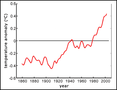
Anomalies are often used, rather than absolute measures, as the nature of the data frequently shows changes in quantities better than absolute. The anomaly is plotted against some reference figure, in this case the 1961 to 1990 average temperature. As shown, global average surface temperatures have been higher than this average for at least 20 years. Also, since 1979, land temperatures have increased about twice as fast as ocean temperatures, 0.25oC per decade against 0.13oC per decade respectively (Smith, 2005). Update: 11 of the last 12 years (1995-2006) were among the warmest on the surface temperature record.
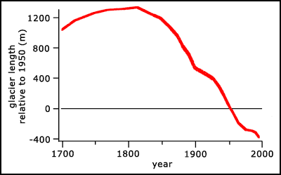
Glaciers are recognized as one of the most sensitive indicators of climate change, advancing substantially during climate cooling (e.g. the Little Ice Age) and retreating during climate warming, over moderate time scales. Glacier lengths have been measured for hundreds of years. Of the 36 glaciers measured between 1860 and 1900, 35 retreated and 1 advanced. Of the 144 measured between 1900 and 1980, 142 retreated and 2 advanced. Figure 2 shows the average shrinkage of measured glaciers since around 1800.
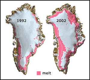
The Greenland ice cap is a massive store of frozen fresh water on land. As shown in figure 3, the year 2002 saw the maximum yearly melt seen so far in the observational record. Surface melting extended up to 6,560 feet (2,000 m) in elevation in the northeast portion of the island, where temperatures normally are too cold for melting to occur. In addition, the total melt area covered 265,000 square miles (686,350 km2), representing a 16% increase above the maximum melt area measured in the past 24 years (Earthobservatory, NASA).
The pattern of glacier melting closely matches the pattern of global average temperature changes. The simplest cause of melting is warming climate, but as the size of glacier is due to a balance between snow accumulation and melting, decreasing snow fall could also lead to the same effect. However, large reductions in snowfall would be required, and the shrinkage of glaciers is a global phenomenon that has occurred steadily over the last century. Most glaciologists therefore deem global warming to be by far the most likely cause of glacial melting.
Update: losses from the ice sheets of Greenland and Antarctica have very likely contributed to sea level rise over 1993 to 2003 (IPCC 2007).
Sea levels may rise due to three reasons:
Data from sea level gauges show that there has been an average increase in sea level of 15cm over the 20th century. It seems likely that thermal expansion accounts for about half of this increase.
Update: global average sea level rose at an average rate of 1.8mm (1.3-2.3mm) per year over 1961 to 2003. The rate was faster over 1993 to 2003, about 3.1mm (2.4-3.8mm) per year (IPCC 2007).
The average arctic sea ice area has also shown a long-term decrease over the last few decades. Figure 4 shows the annually averaged anomalies in sea ice area from 1973 to 2000. There has been an average rate of decrease in sea ice area of 2.8% per decade, with larger decreases in summer of 7.4% (5.0-9.8%) per decade.
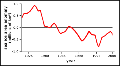
There has also been a thinning of sea ice. Over the last several decades arctic sea ice has become about 40% thinner. This data is from the arctic only. The antarctic is more complex, having substantial land ice as well as sea ice masses. It seems that the data from the South Polar region is less easily interpreted than that from the North.
These are used to estimate past climatic variations. They include:
There are also other methods used, such as satellite temperature measurements. What conclusions have been reached from these sources, in answer to the question "is the Earth warming?" The table below summarises the key findings, and clearly shows that the Earth is warming, quite rapidly.
| Type of data | Direction of change | Size of change |
|---|---|---|
| direct surface air temperature | warming | average temperature increased 0.6oC over 20th century, with about half of this occurring since 1980 |
| glaciers | warming | receding on average for at least 200 years. This implies a warming of 0.6oC per century |
| sea-level change | warming | sea-level rose by about 15cm over the 20th century. About half of this was probably due to thermal expansion. |
| sea ice | warming | the area of Arctic sea ice in spring and summer has decreased by up to 15% over the last 50 years. Average thickness has also decreased by 40% over the same period. |
| ocean temperature | warming | the top 300m of ocean has warmed by 0.18oC over the last 50 years |
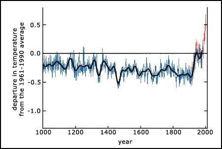
| climate proxies | warming | combined data from many proxies shows gradual Northern hemisphere cooling from 1000AD until the 1800s. Since then there has been strong warming. |
| satellite temperature measurements | warming | satellite instruments show warming of 0.06-0.26oC per decade |
The following extracts come from the IPCC Third Assessment Report summary for policymakers (IPCC, 2001):
Update: "More intense and longer droughts have been observed over wider areas since the 1970s, particularly in the tropics and subtropics"..."frequency of heavy precipitation events has increased over most land areas, consistent with warming and observed increases of atmospheric water vapour"..."flow speed has increased for some Greenland and Antarctic outlet glaciers, which drain ice from the interior of the ice sheets" (IPCC 2007).
There is now strong evidence of a rapidly warming world, which has been reinforced in the latest IPCC report. The next page (climate change 2) addresses the question: "is this recent global warming primarily the human race's fault?"


 Climate change 1
